Basic Information
 Currency of bangladesh
Official Name
The People's Republic Of Bangladesh
Capital
Dhaka (Area 414 sq. km. Master plan 777 sq.km.)
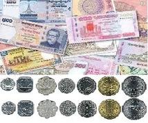
Currency
Currency unit is Taka. Notes are of 1,2,5,10,20,50,100, 500 and 1000 Taka. Coins are of 1,5,10,25,50 Poisha and 1, 2, 5 taka (1 Taka = 100 Poisha )
Language
Bangla is the state language. English is also widely spoken and understood. Arabic is read and spoken for religious purposes
Population
Total estimated population about 160 million.
Religions
Muslim 88.3%, Hindu 10.5%, others 1.2%
Area:
total: 143,998 km²
land: 130,168 km²
water: 13,830 km²
Location
Latitude from 20 degree 34' to 26 degree 38' north. Longitude from 88 degree 01' to 92 degree 41' east.
Boundary
Bounded by India from the north, east and west, Burma from the south-east and the Bay of Bengal from the south .
Climate
Tropical; cool, dry winter (October to March); hot, humid summer (March to June); cool, rainy monsoon (June to October)
Rainfall
Lowest 47" and highest 136"
National Days
National Martyrs Day ( February 21)
Independence Day ( March 26 )
Victory Day ( December 16)
Principal Rivers
Padma, Meghna, Jamuna, Madhumati, Brahmaputra, Surma and Kushiara
Principal Crops
Rice, jute, tea, sugarcane, vegetables, potato, pulses, etc.
Fruits
Mango, banana, pineapple, jack-fruit, water-melon, green coconut, guava etc.
Major Industries
Jute, sugar, paper, textiles, fertilizers, cigarette, cement, steel, natural gas, oil-refinery, newsprint, power generation, rayon, matches, fishing and food processing, leather, soap, carpet, timber, ship-building, telephone, etc.
The People's Republic Of Bangladesh
Capital
Dhaka (Area 414 sq. km. Master plan 777 sq.km.)
Currency
Currency unit is Taka. Notes are of 1,2,5,10,20,50,100, 500 and 1000 Taka. Coins are of 1,5,10,25,50 Poisha and 1, 2, 5 taka (1 Taka = 100 Poisha )
Language
Bangla is the state language. English is also widely spoken and understood. Arabic is read and spoken for religious purposes
Population
Total estimated population about 160 million.
Religions
Muslim 88.3%, Hindu 10.5%, others 1.2%
Area:
total: 143,998 km²
land: 130,168 km²
water: 13,830 km²
Location
Latitude from 20 degree 34' to 26 degree 38' north. Longitude from 88 degree 01' to 92 degree 41' east.
Boundary
Bounded by India from the north, east and west, Burma from the south-east and the Bay of Bengal from the south .
Climate
Tropical; cool, dry winter (October to March); hot, humid summer (March to June); cool, rainy monsoon (June to October)
Rainfall
Lowest 47" and highest 136"
National Days
National Martyrs Day ( February 21)
Independence Day ( March 26 )
Victory Day ( December 16)
Principal Rivers
Padma, Meghna, Jamuna, Madhumati, Brahmaputra, Surma and Kushiara
Principal Crops
Rice, jute, tea, sugarcane, vegetables, potato, pulses, etc.
Fruits
Mango, banana, pineapple, jack-fruit, water-melon, green coconut, guava etc.
Major Industries
Jute, sugar, paper, textiles, fertilizers, cigarette, cement, steel, natural gas, oil-refinery, newsprint, power generation, rayon, matches, fishing and food processing, leather, soap, carpet, timber, ship-building, telephone, etc.
